
Querétaro topographic map
Interactive map
Click on the map to display elevation.
About this map
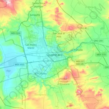
Name: Querétaro topographic map, elevation, terrain.
Average elevation: 6,447 ft
Minimum elevation: 5,853 ft
Maximum elevation: 8,064 ft
Three of Mexico’s geographic zones cover parts of the state. The Mesa del Centro is in the center-west of the state, and mostly consists of small mesas with an average altitude of 2,000 meters (6,562 feet) above sea level (ASL). A few elevations reach over 3,000 meters (9,843 feet). The Sierra Madre Oriental occupies the northeast of the state and includes the cities of Huasteca area. The topography of this area is rugged, with long mountain chains and narrow valleys. Elevations here range between 900 m (2,953 ft) and 3,000 m (9,843 ft) m ASL. The Trans-Mexican Volcanic Belt occupies about half of the state in the center and south. The area is mostly volcanic rock with peaks and mesas between 200 m (656 ft) and 3,000 m (9,843 ft) and valleys between 1,800 m (5,906 ft) and 1,900 m (6,234 ft) ASL.