
Gunung Sinabung topographic map
Interactive map
Click on the map to display elevation.
About this map
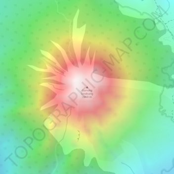
Name: Gunung Sinabung topographic map, elevation, terrain.
Location: Gunung Sinabung, Karo, North Sumatra, Indonesia (3.17090 98.39200 3.17100 98.39210)
Average elevation: 6,020 ft
Minimum elevation: 4,570 ft
Maximum elevation: 7,966 ft
Other topographic maps
Click on a map to view its topography, its elevation and its terrain.
Mount Sibayak
Indonesia > North Sumatra > Karo
Mount Sibayak, Karo, North Sumatra, Sumatra, 22156, Indonesia
Average elevation: 5,758 ft
Sibayak
Indonesia > North Sumatra > Karo > Berastagi
Sibayak, Berastagi, Karo, North Sumatra, Sumatra, 22153, Indonesia
Average elevation: 4,754 ft
Berastagi
Indonesia > North Sumatra > Karo
Berastagi, Karo, North Sumatra, Indonesia
Average elevation: 4,652 ft
Kampung Merdeka
Indonesia > North Sumatra > Karo > Kampung Merdeka
Kampung Merdeka, Karo, North Sumatra, 22153, Indonesia
Average elevation: 4,816 ft