
Seraing topographic map
Interactive map
Click on the map to display elevation.
About this map
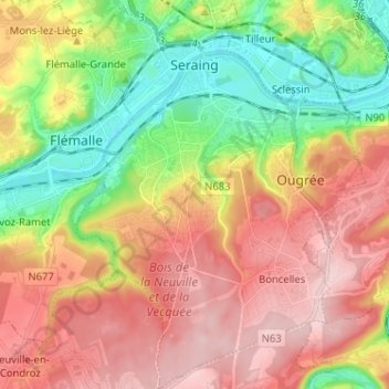
Name: Seraing topographic map, elevation, terrain.
Location: Seraing, Liège, Wallonia, 4100, Belgium (50.54723 5.46989 50.62861 5.56555)
Average elevation: 548 ft
Minimum elevation: 180 ft
Maximum elevation: 902 ft
Other topographic maps
Click on a map to view its topography, its elevation and its terrain.
Comblain-au-Pont
Comblain-au-Pont, Liège, Wallonia, Belgium
Average elevation: 656 ft
Rotheux-Rimière
Belgium > Liège > Liège > Rotheux-Rimière
Rotheux-Rimière, Neupré, Liège, Wallonia, 4120, Belgium
Average elevation: 764 ft
La Corniche
Belgium > Liège > Liège > Esneux
La Corniche, Esneux, Liège, Wallonia, 4130, Belgium
Average elevation: 512 ft
Chaudfontaine
Chaudfontaine, Liège, Wallonia, 4050, Belgium
Average elevation: 617 ft