
Nahuel Huapi National Park topographic map
Interactive map
Click on the map to display elevation.
About this map
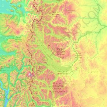
Name: Nahuel Huapi National Park topographic map, elevation, terrain.
Average elevation: 3,481 ft
Minimum elevation: 0 ft
Maximum elevation: 10,574 ft
Other topographic maps
Click on a map to view its topography, its elevation and its terrain.
Embalse de Pichi Picún Leufú
Embalse de Pichi Picún Leufú, Departamento Collón Curá, NQN, Argentina
Average elevation: 1,657 ft