
Forest of Dean topographic map
Interactive map
Click on the map to display elevation.
About this map
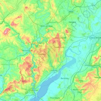
Name: Forest of Dean topographic map, elevation, terrain.
Average elevation: 282 ft
Minimum elevation: -13 ft
Maximum elevation: 1,388 ft
Other topographic maps
Click on a map to view its topography, its elevation and its terrain.
St. Briavels
United Kingdom > England > Forest of Dean
St. Briavels, Forest of Dean, Gloucestershire, South West England, England, United Kingdom
Average elevation: 482 ft