
Caparaó National Park topographic map
Interactive map
Click on the map to display elevation.
About this map
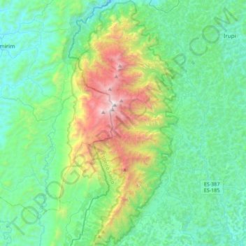
Name: Caparaó National Park topographic map, elevation, terrain.
Average elevation: 3,586 ft
Minimum elevation: 1,932 ft
Maximum elevation: 9,364 ft
Altitude ranges from 997 to 2,890 metres (3,271 to 9,482 ft). The park contains the third highest peak in Brazil, the 2,892 metres (9,488 ft) Pico da Bandeira. Ten other peaks are over 2,000 metres (6,600 ft) in altitude. It protects the watersheds of the Itabapoana, Itapemirim and Doce rivers. Annual rainfall is about 1,000 millimetres (39 in). Average temperatures range from 19 to 22 °C (66 to 72 °F), but in winter (June and July) it is common to have temperatures below freezing at the higher altitudes.
Other topographic maps
Click on a map to view its topography, its elevation and its terrain.
Serra do Caparaó
Brazil > Espírito Santo > Ibitirama
Serra do Caparaó, Santa Marta, Ibitirama, Região Geográfica Imediata de Alegre, Região Geográfica Intermediária de Cachoeiro de Itapemirim, Espírito Santo, Southeast Region, Brazil
Average elevation: 5,758 ft