
Pemalang topographic map
Interactive map
Click on the map to display elevation.
About this map
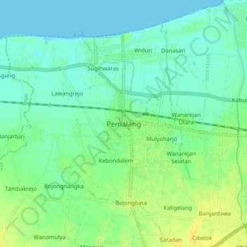
Name: Pemalang topographic map, elevation, terrain.
Location: Pemalang, Central Java, 52361, Indonesia (-6.93036 109.34065 -6.85036 109.42065)
Average elevation: 26 ft
Minimum elevation: 0 ft
Maximum elevation: 66 ft
Other topographic maps
Click on a map to view its topography, its elevation and its terrain.
Slamet
Indonesia > Central Java > Pemalang
Slamet, Pemalang, Central Java, Indonesia
Average elevation: 9,642 ft