
Andipsara topographic map
Interactive map
Click on the map to display elevation.
About this map
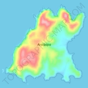
Name: Andipsara topographic map, elevation, terrain.
Average elevation: 95 ft
Minimum elevation: 0 ft
Maximum elevation: 469 ft
Other topographic maps
Click on a map to view its topography, its elevation and its terrain.
Chios
Greece > Aegean > Chios Regional Unit
Chios, Chios Municipality, Chios Regional Unit, Northern Aegean, Aegean, 821 31, Greece
Average elevation: 269 ft
Chios
Greece > Aegean > Chios Regional Unit
Chios, Chios Regional Unit, Northern Aegean, Aegean, Greece
Average elevation: 325 ft
Oinousses
Greece > Aegean > Chios Regional Unit > Inousses
Oinousses, Inousses, Oinousses Municipality, Chios Regional Unit, Northern Aegean, Aegean, 821 01, Greece
Average elevation: 43 ft