
Wijnendale topographic map
Interactive map
Click on the map to display elevation.
About this map
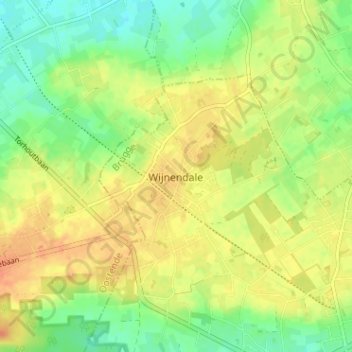
Name: Wijnendale topographic map, elevation, terrain.
Location: Wijnendale, Torhout, Brugge, West-Vlaanderen, 8211, België (51.07220 3.04875 51.11220 3.08875)
Average elevation: 105 ft
Minimum elevation: 43 ft
Maximum elevation: 161 ft
Wijnendale ligt op het Plateau van Wijnendale, een plateau in landschap op ongeveer 40 meter hoogte, 20 meter hoger dan het lagere omliggende land.
Other topographic maps
Click on a map to view its topography, its elevation and its terrain.
Torhout
België > West-Vlaanderen > Brugge > Torhout
Torhout, Brugge, West-Vlaanderen, Vlaanderen, 8820, België
Average elevation: 72 ft
De Driekoningen
België > West-Vlaanderen > Brugge > Torhout
De Driekoningen, Torhout, Brugge, West-Vlaanderen, Vlaanderen, 8820, België
Average elevation: 92 ft