
Apia topographic map
Interactive map
Click on the map to display elevation.
About this map
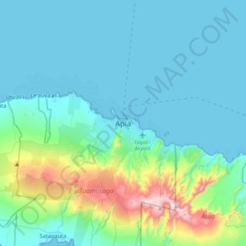
Name: Apia topographic map, elevation, terrain.
Location: Apia, Tuamasaga, Samoa (-13.99446 -171.92491 -13.67446 -171.60491)
Average elevation: 571 ft
Minimum elevation: 0 ft
Maximum elevation: 3,766 ft
Apia is situated on a natural harbour at the mouth of the Vaisigano River. It is on a narrow coastal plain with Mount Vaea (elevation 472 metres (1,549 ft)), the burial place of writer Robert Louis Stevenson, directly to its south. Two main ridges run south on either side of the Vaisigano River, with roads on each. The more western of these is Cross Island Road, one of the few roads cutting north to south across the middle of the island to the south coast of Upolu.
Other topographic maps
Click on a map to view its topography, its elevation and its terrain.