
L'Indre topographic map
Interactive map
Click on the map to display elevation.
About this map
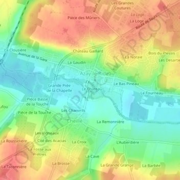
Name: L'Indre topographic map, elevation, terrain.
Average elevation: 226 ft
Minimum elevation: 121 ft
Maximum elevation: 341 ft
Other topographic maps
Click on a map to view its topography, its elevation and its terrain.
Château du Val d'Auray (ou d'Aulnay)
France > Centre-Val de Loire > Azay-le-Rideau
Château du Val d'Auray (ou d'Aulnay), Chemin Rural de la Bréfaudière à Veau, Azay-le-Rideau, Tours, Indre-et-Loire, Centre-Val de Loire, France métropolitaine, 37190, France
Average elevation: 233 ft