
Pumori topographic map
Interactive map
Click on the map to display elevation.
About this map
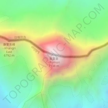
Name: Pumori topographic map, elevation, terrain.
Location: Pumori, Tingri County, Shigatse, Tibet, China (28.01599 86.82735 28.01609 86.82745)
Average elevation: 19,898 ft
Minimum elevation: 17,703 ft
Maximum elevation: 23,481 ft
Other topographic maps
Click on a map to view its topography, its elevation and its terrain.
Third Step
China > Tibet > Tingri County > Qutang
Third Step, Qutang, Tingri County, Shigatse Prefecture, Tibet, China
Average elevation: 25,840 ft