
Ljusdals kommun topographic map
Interactive map
Click on the map to display elevation.
About this map
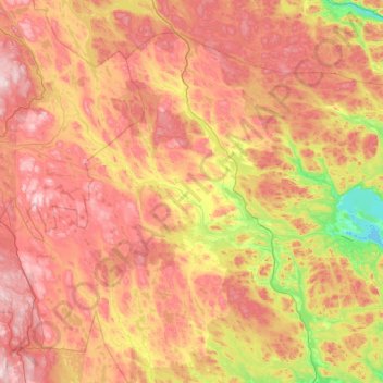
Name: Ljusdals kommun topographic map, elevation, terrain.
Location: Ljusdals kommun, Gävleborg County, Sweden (61.48410 14.44665 62.34351 16.63282)
Average elevation: 1,040 ft
Minimum elevation: 125 ft
Maximum elevation: 2,379 ft
Other topographic maps
Click on a map to view its topography, its elevation and its terrain.
Söderala
Söderala, Söderhamns kommun, Gävleborg County, 826 61, Sweden
Average elevation: 125 ft
Grängsjö
Grängsjö, Hudiksvalls kommun, Gävleborg County, Sweden
Average elevation: 489 ft
Gnarp District
Gnarp District, Nordanstigs kommun, Gävleborg County, Sweden
Average elevation: 105 ft
Glöte
Glöte, Hudiksvalls kommun, Gävleborg County, 820 64, Sweden
Average elevation: 207 ft
Trödje
Trödje, Gävle kommun, Gävleborg County, 805 96, Sweden
Average elevation: 36 ft
Gävle kommun
Gävle kommun, Gävleborg County, Sweden
Average elevation: 200 ft
Lottefors
Lottefors, Bollnäs kommun, Gävleborg County, Sweden
Average elevation: 410 ft
Vallåsen
Vallåsen, Hudiksvalls kommun, Gävleborg County, Sweden
Average elevation: 735 ft
Ovanåkers kommun
Ovanåkers kommun, Gävleborg County, Sweden
Average elevation: 883 ft
Gästrike-Hammarby
Gästrike-Hammarby, Sandvikens kommun, Gävleborg County, Sweden
Average elevation: 256 ft
Hofors kommun
Hofors kommun, Gävleborg County, Sweden
Average elevation: 482 ft
Sandviken
Sandviken, Sandvikens kommun, Gävleborg County, 811 39, Sweden
Average elevation: 240 ft
Hudiksvall
Hudiksvall, Hudiksvalls kommun, Gävleborg County, 824 23, Sweden
Average elevation: 108 ft
Ockelbo kommun
Ockelbo kommun, Gävleborg County, Sweden
Average elevation: 594 ft