
Anjarle topographic map
Interactive map
Click on the map to display elevation.
About this map
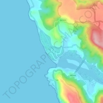
Name: Anjarle topographic map, elevation, terrain.
Location: Anjarle, Dapoli, Ratnagiri, Maharashtra, 415714, India (17.82758 73.07028 17.86758 73.11028)
Average elevation: 121 ft
Minimum elevation: 0 ft
Maximum elevation: 617 ft
Other topographic maps
Click on a map to view its topography, its elevation and its terrain.
Suwarnadadh fort
India > Maharashtra > Dapoli > Pajpandhari
Suwarnadadh fort, MSH4, Navi Bazar Peth, Pajpandhari, Dapoli, Ratnagiri, Maharashtra, 415713, India
Average elevation: 16 ft