
Hamburg topographic map
Interactive map
Click on the map to display elevation.
About this map
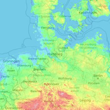
Name: Hamburg topographic map, elevation, terrain.
Location: Hamburg, Germany (50.98376 7.44991 56.10376 12.56991)
Average elevation: 184 ft
Minimum elevation: -20 ft
Maximum elevation: 3,524 ft
The neighborhoods of Neuenfelde, Cranz, Francop and Finkenwerder are part of the Altes Land (old land) region, the largest contiguous fruit-producing region in Central Europe. Neugraben-Fischbek has Hamburg's highest elevation, the Hasselbrack at 116.2 metres (381 ft) AMSL. Hamburg borders the states of Schleswig-Holstein and Lower Saxony.
Other topographic maps
Click on a map to view its topography, its elevation and its terrain.
Barmbek-Nord
Barmbek-Nord, Hamburg-Nord, Hamburg, Germany
Average elevation: 52 ft
Horner Park
Horner Park, Horn, Hamburg-Mitte, Hamburg, 22111, Germany
Average elevation: 39 ft