
Kramfors kommun topographic map
Interactive map
Click on the map to display elevation.
About this map
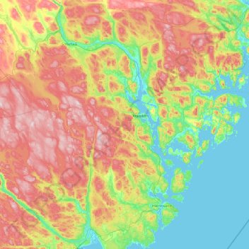
Name: Kramfors kommun topographic map, elevation, terrain.
Location: Kramfors kommun, Västernorrland County, Sweden (62.59358 17.17881 63.20533 18.99320)
Average elevation: 535 ft
Minimum elevation: -13 ft
Maximum elevation: 1,562 ft
Other topographic maps
Click on a map to view its topography, its elevation and its terrain.
Mosjö
Sweden > Västernorrland County > Skorped District
Mosjö, Skorped District, Örnsköldsviks kommun, Västernorrland County, Sweden
Average elevation: 610 ft
Grundtjärn
Sweden > Västernorrland County > Anundsjö District
Grundtjärn, Anundsjö District, Örnsköldsviks kommun, Västernorrland County, Sweden
Average elevation: 912 ft
Dyön
Sweden > Västernorrland County > Nora District
Dyön, Nora District, Kramfors kommun, Västernorrland County, Sweden
Average elevation: 26 ft
Sundsvall
Sweden > Västernorrland County
Sundsvall, Sundsvall Municipality, Västernorrland County, Sweden
Average elevation: 230 ft
Örnsköldsvik
Sweden > Västernorrland County
Örnsköldsvik, Örnsköldsviks kommun, Västernorrland County, Sweden
Average elevation: 213 ft