
Fuente Álamo de Murcia topographic map
Interactive map
Click on the map to display elevation.
About this map
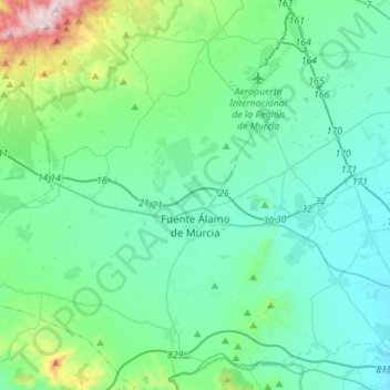
Name: Fuente Álamo de Murcia topographic map, elevation, terrain.
Average elevation: 709 ft
Minimum elevation: 164 ft
Maximum elevation: 3,478 ft
Other topographic maps
Click on a map to view its topography, its elevation and its terrain.
Monte Sacro
Spain > Region of Murcia > Campo de Cartagena y Mar Menor > Cartagena
Monte Sacro, Cartagena, Campo de Cartagena y Mar Menor, Region of Murcia, 30203, Spain
Average elevation: 39 ft
San Pedro del Pinatar
Spain > Region of Murcia > Campo de Cartagena y Mar Menor
San Pedro del Pinatar, Campo de Cartagena y Mar Menor, Region of Murcia, 30740, Spain
Average elevation: 56 ft
Los Alcázares
Spain > Region of Murcia > Campo de Cartagena y Mar Menor
Los Alcázares, Campo de Cartagena y Mar Menor, Region of Murcia, 30710, Spain
Average elevation: 30 ft
San Javier
Spain > Region of Murcia > Campo de Cartagena y Mar Menor
San Javier, Campo de Cartagena y Mar Menor, Region of Murcia, Spain
Average elevation: 95 ft