
Ålands Countryside topographic map
Interactive map
Click on the map to display elevation.
About this map
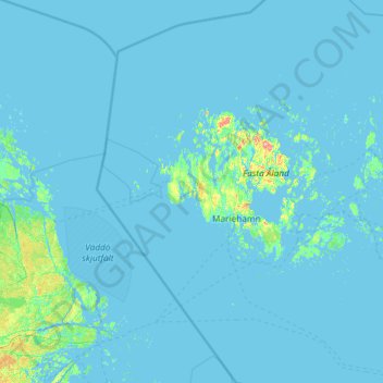
Name: Ålands Countryside topographic map, elevation, terrain.
Location: Ålands Countryside, Åland Islands, Finland (59.59506 19.08320 60.76201 20.37812)
Average elevation: 10 ft
Minimum elevation: -16 ft
Maximum elevation: 387 ft
Other topographic maps
Click on a map to view its topography, its elevation and its terrain.
Hammarland
Hammarland, Ålands Countryside, Åland Islands, 22240, Finland
Average elevation: 10 ft
Mariehamn sub-region
Mariehamn sub-region, Åland Islands, Finland
Average elevation: 23 ft