
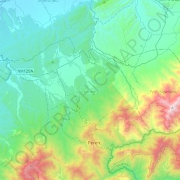
Jalukie topographic map
Interactive map
Click on the map to display elevation.
About this map
Name: Jalukie topographic map, elevation, terrain.
Location: Jalukie, Peren District, Nagaland, India (25.54058 93.50648 25.70174 93.81071)
Average elevation: 2,244 ft
Minimum elevation: 558 ft
Maximum elevation: 8,048 ft
Other topographic maps
Click on a map to view its topography, its elevation and its terrain.
Kebai Khelma
Kebai Khelma, Peren District, Nagaland, India
Average elevation: 2,625 ft
Chessore Village
Chessore Village, Chessore, Tuensang, Nagaland, India
Average elevation: 4,347 ft
Mokokchung
India > Nagaland > ONGPANGKONG (N)
Mokokchung, ONGPANGKONG (N), Mokokchung District, Nagaland, 798601, India
Average elevation: 3,369 ft
Kohima
India > Nagaland > Kohima Sadar
Kohima, Kohima Sadar, Kohima District, Nagaland, 797001, India
Average elevation: 4,675 ft