
Buffelskloof topographic map
Interactive map
Click on the map to display elevation.
About this map
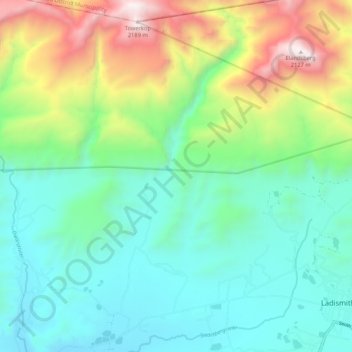
Name: Buffelskloof topographic map, elevation, terrain.
Average elevation: 2,959 ft
Minimum elevation: 1,355 ft
Maximum elevation: 6,972 ft
Other topographic maps
Click on a map to view its topography, its elevation and its terrain.
Touws River
South Africa > Western Cape > Kannaland Local Municipality
Touws River, Kannaland Local Municipality, Garden Route District Municipality, Western Cape, South Africa
Average elevation: 886 ft
Brak River
South Africa > Western Cape > Kannaland Local Municipality
Brak River, Kannaland Local Municipality, Garden Route District Municipality, Western Cape, South Africa
Average elevation: 1,854 ft