
Verbier topographic map
Interactive map
Click on the map to display elevation.
About this map
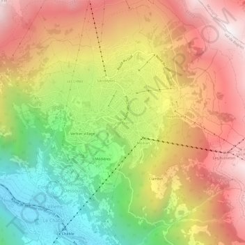
Name: Verbier topographic map, elevation, terrain.
Location: Verbier, Val de Bagnes, Entremont, Wallis, 1934, Switzerland (46.07610 7.20868 46.11610 7.24868)
Average elevation: 5,335 ft
Minimum elevation: 2,628 ft
Maximum elevation: 7,871 ft
Other topographic maps
Click on a map to view its topography, its elevation and its terrain.
Savu
Switzerland > Wallis > Entremont > Sembrancher
Savu, Sembrancher, Entremont, Wallis, 2303, Switzerland
Average elevation: 3,081 ft
Val de Bagnes
Switzerland > Wallis > Entremont
Val de Bagnes, Entremont, Wallis, 1934, Switzerland
Average elevation: 7,615 ft
Maligue
Switzerland > Wallis > Entremont > La Rosière
Maligue, La Rosière, Orsières, Entremont, Wallis, 2303, Switzerland
Average elevation: 4,380 ft
Mont Dolent / Monte Dolent
Switzerland > Wallis > Entremont > Orsières
Mont Dolent / Monte Dolent, Orsières, Entremont, Wallis, 2303, Switzerland
Average elevation: 10,203 ft
Le Bry
Switzerland > Wallis > Entremont > Verbier
Le Bry, Fontenelle-Dessus, Verbier, Val de Bagnes, Entremont, Wallis, 1934, Switzerland
Average elevation: 4,767 ft
Le Clou
Switzerland > Wallis > Entremont > La Fouly
Le Clou, La Fouly, Orsières, Entremont, Wallis, 2303, Switzerland
Average elevation: 6,591 ft