
Aizawl topographic map
Interactive map
Click on the map to display elevation.
About this map
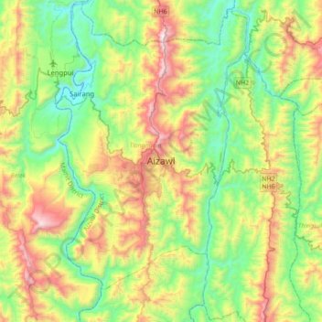
Name: Aizawl topographic map, elevation, terrain.
Location: Aizawl, Tlangnuam, Aizwal District, Mizoram, 796190, India (23.58335 92.57828 23.90335 92.89828)
Average elevation: 1,824 ft
Minimum elevation: 197 ft
Maximum elevation: 4,951 ft
Aizawl has a mild, sub-tropical climate due to its location and elevation. Under the Köppen climate classification, Aizawl features a humid subtropical climate (Cwa) but very rainy. In the summer the temperature ranges from 20–30 °C (68–86 °F), and in the winter 11–21 °C (52–70 °F).