
Roorkee topographic map
Interactive map
Click on the map to display elevation.
About this map
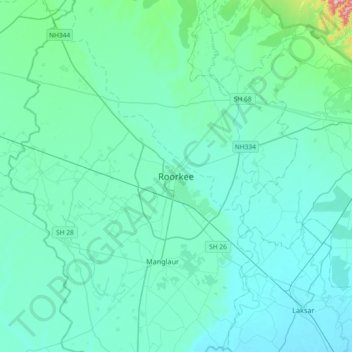
Name: Roorkee topographic map, elevation, terrain.
Location: Roorkee, Haridwar District, Uttarakhand, 247667, India (29.70935 77.73021 30.02935 78.05021)
Average elevation: 886 ft
Minimum elevation: 764 ft
Maximum elevation: 1,995 ft
Roorkee is located at 29°52′N 77°53′E / 29.87°N 77.88°E / 29.87; 77.88. It has an average elevation of 268 metres (879 ft).