
São Domingos de Rana topographic map
Interactive map
Click on the map to display elevation.
About this map
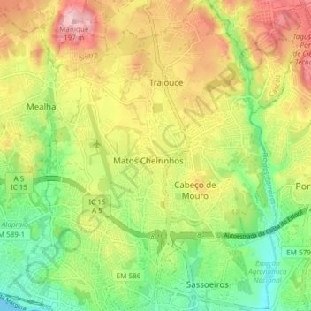
Name: São Domingos de Rana topographic map, elevation, terrain.
Location: São Domingos de Rana, Cascais, Lisboa, Portugal (38.69364 -9.37035 38.75214 -9.30807)
Average elevation: 299 ft
Minimum elevation: 0 ft
Maximum elevation: 656 ft
Other topographic maps
Click on a map to view its topography, its elevation and its terrain.
Malveira da Serra
Malveira da Serra, Alcabideche, Cascais, Lisboa, 2755-296, Portugal
Average elevation: 594 ft
Praia de Carcavelos
Praia de Carcavelos, Carcavelos e Parede, Cascais, Lisboa, Portugal
Average elevation: 36 ft
Alcabideche
Alcabideche, Cascais, Lisboa, Portugal
Average elevation: 469 ft
São Pedro do Estoril
São Pedro do Estoril, Cascais e Estoril, Cascais, Lisboa, 2765-542, Portugal
Average elevation: 95 ft