
Helena topographic map
Interactive map
Click on the map to display elevation.
About this map
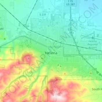
Name: Helena topographic map, elevation, terrain.
Location: Helena, Lewis and Clark County, Montana, United States (46.55922 -112.08328 46.62948 -111.95157)
Average elevation: 4,252 ft
Minimum elevation: 3,701 ft
Maximum elevation: 5,712 ft
Helena is located at 46°35′45″N 112°1′37″W / 46.59583°N 112.02694°W / 46.59583; -112.02694 (46.595805, −112.027031), at an altitude of 4,058 feet (1,237 m).
Other topographic maps
Click on a map to view its topography, its elevation and its terrain.
Craig
United States > Montana > Lewis and Clark County
Craig, Lewis and Clark County, Montana, United States
Average elevation: 3,596 ft
Augusta
United States > Montana > Lewis and Clark County > Augusta
Augusta, Lewis and Clark County, Montana, 59410, United States
Average elevation: 4,088 ft
Frontier Town
United States > Montana > Lewis and Clark County
Frontier Town, Lewis and Clark County, Montana, United States
Average elevation: 6,135 ft
Broadwater
United States > Montana > Lewis and Clark County
Broadwater, Lewis and Clark County, Montana, 59636, United States
Average elevation: 4,213 ft
York
United States > Montana > Lewis and Clark County
York, Lewis and Clark County, Montana, United States
Average elevation: 4,423 ft
Sugar Loaf
United States > Montana > Lewis and Clark County
Sugar Loaf, Lewis and Clark County, Montana, United States
Average elevation: 6,171 ft
Devils Tower
United States > Montana > Lewis and Clark County
Devils Tower, Lewis and Clark County, Montana, United States
Average elevation: 4,505 ft
Canyon Point
United States > Montana > Lewis and Clark County
Canyon Point, Lewis and Clark County, Montana, United States
Average elevation: 6,827 ft
Mount Helena
United States > Montana > Lewis and Clark County > Helena
Mount Helena, Helena, Lewis and Clark County, Montana, 59601, United States
Average elevation: 4,554 ft