
Castricum topographic map
Interactive map
Click on the map to display elevation.
About this map
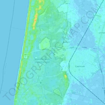
Name: Castricum topographic map, elevation, terrain.
Location: Castricum, Noord-Holland, Nederland (52.52673 4.58332 52.59090 4.69761)
Average elevation: 10 ft
Minimum elevation: -7 ft
Maximum elevation: 92 ft
Topografisch kaartbeeld van de gemeente Castricum, per september 2022
Other topographic maps
Click on a map to view its topography, its elevation and its terrain.
Limmen
Nederland > Noord-Holland > Castricum
Limmen, Castricum, Noord-Holland, Nederland
Average elevation: 3 ft
Akersloot
Nederland > Noord-Holland > Castricum
Akersloot, Castricum, Noord-Holland, Nederland
Average elevation: -3 ft
Alkmaardermeer
Nederland > Noord-Holland > Castricum
Alkmaardermeer, Castricum, Noord-Holland, Nederland, 1921CA, Nederland
Average elevation: -7 ft
Bakkum
Nederland > Noord-Holland > Castricum
Bakkum, Castricum, Noord-Holland, Nederland, 1901 MA, Nederland
Average elevation: 10 ft
Noord-Bakkum
Nederland > Noord-Holland > Castricum > Noord-Bakkum
Noord-Bakkum, Castricum, Noord-Holland, Nederland, 1901, Nederland
Average elevation: 10 ft