
Opdorp topographic map
Interactive map
Click on the map to display elevation.
About this map
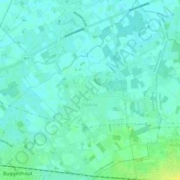
Name: Opdorp topographic map, elevation, terrain.
Average elevation: 23 ft
Minimum elevation: 7 ft
Maximum elevation: 62 ft
Other topographic maps
Click on a map to view its topography, its elevation and its terrain.
Buggenhout
België > Oost-Vlaanderen > Dendermonde > Buggenhout
Buggenhout, Dendermonde, Oost-Vlaanderen, Vlaanderen, 9255, België
Average elevation: 39 ft
Opstal
België > Oost-Vlaanderen > Dendermonde > Buggenhout
Opstal, Buggenhout, Dendermonde, Oost-Vlaanderen, 9255, België
Average elevation: 43 ft