
Sipsey Wilderness topographic map
Interactive map
Click on the map to display elevation.
About this map
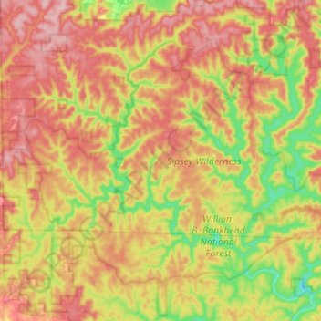
Name: Sipsey Wilderness topographic map, elevation, terrain.
Location: Sipsey Wilderness, Lawrence County, Alabama, United States (34.28044 -87.51880 34.39012 -87.34639)
Average elevation: 833 ft
Minimum elevation: 535 ft
Maximum elevation: 1,070 ft
Other topographic maps
Click on a map to view its topography, its elevation and its terrain.
Speake
United States > Alabama > Lawrence County
Speake, Lawrence County, Alabama, United States
Average elevation: 646 ft
Moulton
United States > Alabama > Lawrence County
Moulton, Lawrence County, Alabama, 35650, United States
Average elevation: 650 ft
Green Bluff Mountain
United States > Alabama > Lawrence County
Green Bluff Mountain, Lawrence County, Alabama, 35672, United States
Average elevation: 650 ft
Mount Hope
United States > Alabama > Lawrence County
Mount Hope, Lawrence County, Alabama, 35651, United States
Average elevation: 636 ft