
Libenau topographic map
Interactive map
Click on the map to display elevation.
About this map
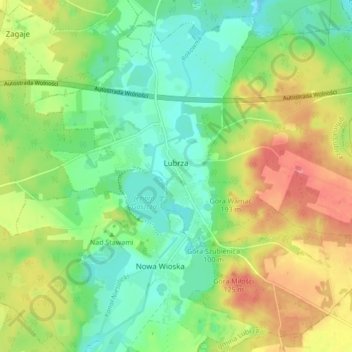
Name: Libenau topographic map, elevation, terrain.
Average elevation: 305 ft
Minimum elevation: 200 ft
Maximum elevation: 456 ft
Other topographic maps
Click on a map to view its topography, its elevation and its terrain.
Przełazy
Polen > Woiwodschaft Lebus > powiat świebodziński > Przełazy
Przełazy, gmina Lubrza, powiat świebodziński, Woiwodschaft Lebus, Polen
Average elevation: 322 ft