
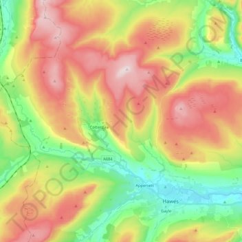
High Abbotside topographic map
Interactive map
Click on the map to display elevation.
About this map
Name: High Abbotside topographic map, elevation, terrain.
Average elevation: 1,463 ft
Minimum elevation: 715 ft
Maximum elevation: 2,346 ft
Other topographic maps
Click on a map to view its topography, its elevation and its terrain.
Great Roova Crags
United Kingdom > England > North Yorkshire > Richmondshire
Great Roova Crags, Richmondshire, North Yorkshire, England, DL8 4RZ, United Kingdom
Average elevation: 1,260 ft
Marrick
United Kingdom > England > North Yorkshire > Richmondshire > Marrick
Marrick, Richmondshire, North Yorkshire, England, United Kingdom
Average elevation: 951 ft
Arkleside
United Kingdom > England > North Yorkshire > Richmondshire > Arkleside
Arkleside, Carlton Highdale, Richmondshire, North Yorkshire, Yorkshire and the Humber, England, DL8 4TU, United Kingdom
Average elevation: 1,247 ft
Ravenseat
United Kingdom > England > North Yorkshire > Richmondshire > Ravenseat
Ravenseat, Muker, Richmondshire, North Yorkshire, Yorkshire and the Humber, England, DL11 6LP, United Kingdom
Average elevation: 1,535 ft
Hunton
United Kingdom > England > North Yorkshire > Richmondshire
Hunton, Richmondshire, North Yorkshire, England, DL8 1QH, United Kingdom
Average elevation: 413 ft
Forcett
United Kingdom > England > North Yorkshire > Richmondshire > Forcett
Forcett, Richmondshire, North Yorkshire, Yorkshire and the Humber, England, DL11 7RX, United Kingdom
Average elevation: 381 ft
Arkengarthdale
United Kingdom > England > North Yorkshire > Richmondshire
Arkengarthdale, Richmondshire, North Yorkshire, Yorkshire and the Humber, England, United Kingdom
Average elevation: 1,467 ft
Cleasby
United Kingdom > England > North Yorkshire > Richmondshire > Cleasby
Cleasby, Richmondshire, North Yorkshire, Yorkshire and the Humber, England, United Kingdom
Average elevation: 184 ft
Arkle Town
United Kingdom > England > North Yorkshire > Richmondshire > Arkle Town
Arkle Town, Arkengarthdale, Richmondshire, North Yorkshire, Yorkshire and the Humber, England, DL11 6RB, United Kingdom
Average elevation: 1,204 ft
Swinithwaite
United Kingdom > England > North Yorkshire > Richmondshire > West Witton > Swinithwaite
Swinithwaite, West Witton, Richmondshire, North Yorkshire, Yorkshire and the Humber, England, DL8 4UH, United Kingdom
Average elevation: 673 ft
Scorton
United Kingdom > England > North Yorkshire > Richmondshire > Scorton
Scorton, Richmondshire, North Yorkshire, Yorkshire and the Humber, England, DL10 6DR, United Kingdom
Average elevation: 194 ft
East Hauxwell
United Kingdom > England > North Yorkshire > Richmondshire
East Hauxwell, Richmondshire, North Yorkshire, England, United Kingdom
Average elevation: 666 ft
Keld
United Kingdom > England > North Yorkshire > Richmondshire
Keld, Muker, Richmondshire, North Yorkshire, England, DL11 6LJ, United Kingdom
Average elevation: 1,407 ft
Appersett
United Kingdom > England > North Yorkshire > Richmondshire > Appersett
Appersett, Richmondshire, North Yorkshire, England, DL8 3LN, United Kingdom
Average elevation: 1,004 ft
Grinton
United Kingdom > England > North Yorkshire > Richmondshire
Grinton, Richmondshire, North Yorkshire, England, DL11 6HH, United Kingdom
Average elevation: 958 ft
Marsett
United Kingdom > England > North Yorkshire > Richmondshire
Marsett, Bainbridge, Richmondshire, North Yorkshire, England, DL8 3DG, United Kingdom
Average elevation: 1,234 ft
Whaw
United Kingdom > England > North Yorkshire > Richmondshire
Whaw, Arkengarthdale, Richmondshire, North Yorkshire, England, DL11 6RT, United Kingdom
Average elevation: 1,342 ft
Carperby
United Kingdom > England > North Yorkshire > Richmondshire
Carperby, Richmondshire, North Yorkshire, England, DL8 4DA, United Kingdom
Average elevation: 801 ft
East Layton
United Kingdom > England > North Yorkshire > Richmondshire
East Layton, Richmondshire, North Yorkshire, England, United Kingdom
Average elevation: 463 ft