
Küstrin an der Oder topographic map
Interactive map
Click on the map to display elevation.
About this map
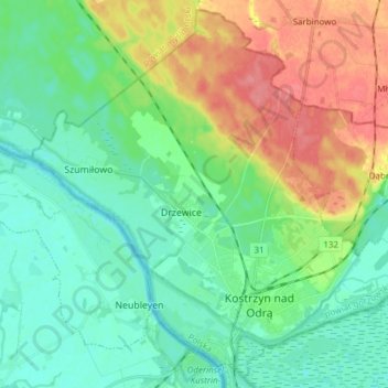
Name: Küstrin an der Oder topographic map, elevation, terrain.
Average elevation: 95 ft
Minimum elevation: 16 ft
Maximum elevation: 253 ft
Other topographic maps
Click on a map to view its topography, its elevation and its terrain.
Schönewald
Polen > Woiwodschaft Lebus > powiat gorzowski
Schönewald, gmina Deszczno, powiat gorzowski, Woiwodschaft Lebus, Polen
Average elevation: 62 ft
Jahnsfelde
Polen > Woiwodschaft Lebus > powiat gorzowski
Jahnsfelde, gmina Santok, powiat gorzowski, Woiwodschaft Lebus, Polen
Average elevation: 190 ft