
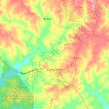
Dawsonville topographic map
Interactive map
Click on the map to display elevation.
About this map
Name: Dawsonville topographic map, elevation, terrain.
Location: Dawsonville, Dawson County, Georgia, United States (34.39788 -84.13500 34.46249 -84.06178)
Average elevation: 1,352 ft
Minimum elevation: 1,152 ft
Maximum elevation: 1,516 ft
Other topographic maps
Click on a map to view its topography, its elevation and its terrain.
Amicalola Falls
United States > Georgia > Dawson County
Amicalola Falls, Dawson County, Georgia, United States
Average elevation: 2,293 ft
Barrettsville
United States > Georgia > Dawson County
Barrettsville, Dawson County, Georgia, United States
Average elevation: 1,175 ft
Amicalola Falls
United States > Georgia > Dawson County
Amicalola Falls, Dawson County, Georgia, United States
Average elevation: 2,310 ft
Amicalola Falls State Park
United States > Georgia > Dawson County
Amicalola Falls State Park, Dawson County, Georgia, United States
Average elevation: 2,336 ft