
Gryfino topographic map
Interactive map
Click on the map to display elevation.
About this map
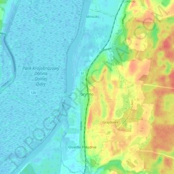
Name: Gryfino topographic map, elevation, terrain.
Average elevation: 52 ft
Minimum elevation: -33 ft
Maximum elevation: 171 ft
Other topographic maps
Click on a map to view its topography, its elevation and its terrain.
Banie
Poland > West Pomeranian Voivodeship > Gryfino County
Banie, gmina Banie, Gryfino County, West Pomeranian Voivodeship, 74-110, Poland
Average elevation: 207 ft