
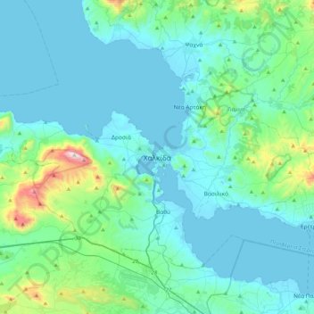
Chalkida topographic map
Interactive map
Click on the map to display elevation.
About this map
Name: Chalkida topographic map, elevation, terrain.
Average elevation: 423 ft
Minimum elevation: -3 ft
Maximum elevation: 3,301 ft
Other topographic maps
Click on a map to view its topography, its elevation and its terrain.
Marmari
Greece > Thessaly and Central Greece > Euboea Regional Unit
Marmari, Karystos Municipality, Euboea Regional Unit, Central Greece, Thessaly and Central Greece, 340 13, Greece
Average elevation: 325 ft
Karystos
Greece > Thessaly and Central Greece > Euboea Regional Unit
Karystos, Karystos Municipality, Euboea Regional Unit, Central Greece, Thessaly and Central Greece, 340 01, Greece
Average elevation: 548 ft
Κάτω Στενή
Greece > Thessaly and Central Greece > Euboea Regional Unit
Κάτω Στενή, Dirfyon - Messapion Municipality, Euboea Regional Unit, Central Greece, Thessaly and Central Greece, 340 14, Greece
Average elevation: 1,211 ft
Αιδηψός
Greece > Thessaly and Central Greece > Euboea Regional Unit
Αιδηψός, Istiaia-Aidipsos Municipality, Euboea Regional Unit, Central Greece, Thessaly and Central Greece, 343 00, Greece
Average elevation: 371 ft
Agios Ioannis
Greece > Thessaly and Central Greece > Euboea Regional Unit
Agios Ioannis, Kymi - Aliveri Anna Municipality, Euboea Regional Unit, Central Greece, Thessaly and Central Greece, 345 00, Greece
Average elevation: 423 ft
Xirovrysi
Greece > Thessaly and Central Greece > Euboea Regional Unit > Municipal Unit of Anthidon
Xirovrysi, Municipal Unit of Anthidon, Municipality of Chalkida, Euboea Regional Unit, Central Greece, Thessaly and Central Greece, 341 31, Greece
Average elevation: 49 ft
Skyros
Greece > Thessaly and Central Greece > Euboea Regional Unit
Skyros, Euboea Regional Unit, Central Greece, Thessaly and Central Greece, 340 07, Greece
Average elevation: 200 ft