
Kuala Terengganu topographic map
Interactive map
Click on the map to display elevation.
About this map
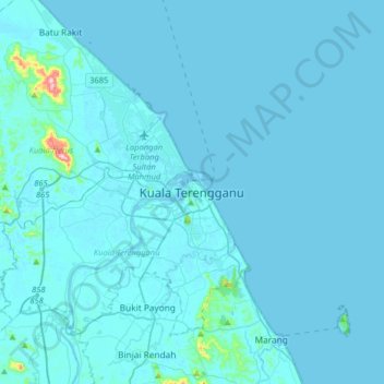
Name: Kuala Terengganu topographic map, elevation, terrain.
Location: Kuala Terengganu, Terengganu, 20300, Malaysia (5.16965 102.97833 5.48965 103.29833)
Average elevation: 30 ft
Minimum elevation: -3 ft
Maximum elevation: 1,050 ft
As a part of Terengganu, Kuala Terengganu has a tropical rainforest climate under the Köppen climate classification (Af) with constant temperature and high humidity. The amount of rainfall varies according to the monsoon season. It is generally fairly hot and humid all year round, averaging from 28 °C to 30 °C in daytime and slightly cooler after dusk. Nevertheless, the sea breeze from South China Sea hsomehow moderates the humidity in offshore areas while the altitude and lush forest trees and plant has cooled the mountain and rural areas.
Other topographic maps
Click on a map to view its topography, its elevation and its terrain.
Batu Buruk Beach
Malaysia > Terengganu > Kuala Terengganu > Kuala Terengganu
Batu Buruk Beach, Batu Buruk, Kuala Terengganu, Terengganu, Malaysia
Average elevation: 13 ft
Kampung Merbau Patah
Malaysia > Terengganu > Kuala Terengganu
Kampung Merbau Patah, Kuala Terengganu, Terengganu, 21000, Malaysia
Average elevation: 26 ft