
Eupen topographic map
Interactive map
Click on the map to display elevation.
About this map
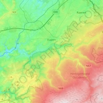
Name: Eupen topographic map, elevation, terrain.
Location: Eupen, Verviers, Liège, Wallonia, Belgium (50.54802 6.00060 50.67287 6.27411)
Average elevation: 1,207 ft
Minimum elevation: 591 ft
Maximum elevation: 2,205 ft
Eupen has a cool oceanic climate with some continental influences due to it being elevated in comparison to most of Belgium. Eupen is also wetter and cloudier than Liège in the valley to the west, as a result of orographic lift due to the elevation change. As a result of this along with frequent winter frosts, Eupen gets a significant snowfall amount by Belgian standards. It also gets 16.8 ice days on average each year, as in the day staying below 0 °C (32 °F).
Other topographic maps
Click on a map to view its topography, its elevation and its terrain.
Robertville
Robertville, Waimes, Verviers, Liège, Wallonia, Belgium
Average elevation: 1,870 ft
Baraque Michel
Belgium > Liège > Verviers > Jalhay
Baraque Michel, Jalhay, Verviers, Liège, Wallonia, 4845, Belgium
Average elevation: 2,139 ft
Arbrefontaine
Belgium > Liège > Verviers > Arbrefontaine
Arbrefontaine, Lierneux, Verviers, Liège, Wallonia, 4990, Belgium
Average elevation: 1,470 ft
Francorchamps
Belgium > Liège > Verviers > Stavelot
Francorchamps, Stavelot, Verviers, Liège, Wallonia, 4970, Belgium
Average elevation: 1,581 ft
Saint Vith
Saint Vith, Verviers, Liège, Wallonia, 4780, Belgium
Average elevation: 1,614 ft
Signal de Botrange
Belgium > Liège > Verviers > Robertville
Signal de Botrange, Robertville, Waimes, Verviers, Liège, Wallonia, Belgium
Average elevation: 2,159 ft
Thimister-Clermont
Thimister-Clermont, Verviers, Liège, Wallonia, 4890, Belgium
Average elevation: 856 ft