
Sherbro Island topographic map
Interactive map
Click on the map to display elevation.
About this map
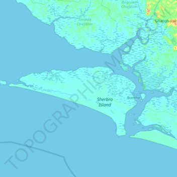
Name: Sherbro Island topographic map, elevation, terrain.
Average elevation: 10 ft
Minimum elevation: -13 ft
Maximum elevation: 614 ft
Other topographic maps
Click on a map to view its topography, its elevation and its terrain.
Kasseh
Sierra Leone > Southern Province > Kasseh
Kasseh, Bonthe District, Southern Province, Sierra Leone
Average elevation: 10 ft