
Neola topographic map
Interactive map
Click on the map to display elevation.
About this map
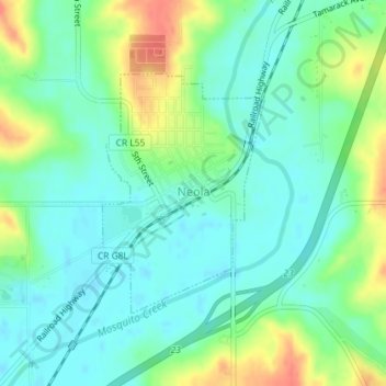
Name: Neola topographic map, elevation, terrain.
Location: Neola, Pottawattamie County, Iowa, United States (41.44059 -95.62428 41.45739 -95.60909)
Average elevation: 1,125 ft
Minimum elevation: 1,070 ft
Maximum elevation: 1,237 ft
Other topographic maps
Click on a map to view its topography, its elevation and its terrain.
Underwood
United States > Iowa > Pottawattamie County
Underwood, Pottawattamie County, Iowa, United States
Average elevation: 1,109 ft
Council Bluffs
United States > Iowa > Pottawattamie County
Council Bluffs, Pottawattamie County, Iowa, United States
Average elevation: 1,033 ft
Crescent
United States > Iowa > Pottawattamie County
Crescent, Pottawattamie County, Iowa, United States
Average elevation: 1,073 ft
Underwood
United States > Iowa > Pottawattamie County > Underwood > Underwood
Underwood, Pottawattamie County, Iowa, 51576, United States
Average elevation: 1,129 ft
Carson
United States > Iowa > Pottawattamie County
Carson, Pottawattamie County, Iowa, 51525, United States
Average elevation: 1,119 ft