
Rennell and Bellona Province topographic map
Interactive map
Click on the map to display elevation.
About this map
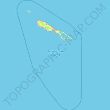
Name: Rennell and Bellona Province topographic map, elevation, terrain.
Location: Rennell and Bellona Province, Solomon Islands (-13.24243 159.54538 -11.06780 160.85561)
Average elevation: 3 ft
Minimum elevation: -7 ft
Maximum elevation: 584 ft
Other topographic maps
Click on a map to view its topography, its elevation and its terrain.
Bellona Island
Solomon Islands > Rennell and Bellona Province
Bellona Island, Rennell and Bellona Province, Solomon Islands
Average elevation: 23 ft
Rennell Island
Solomon Islands > Rennell and Bellona Province
Rennell Island, Rennell and Bellona Province, Solomon Islands
Average elevation: 20 ft