
Devils Tower topographic map
Interactive map
Click on the map to display elevation.
About this map
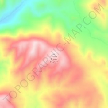
Name: Devils Tower topographic map, elevation, terrain.
Average elevation: 4,505 ft
Minimum elevation: 3,760 ft
Maximum elevation: 5,085 ft
Other topographic maps
Click on a map to view its topography, its elevation and its terrain.
Helena
United States > Montana > Lewis and Clark County
Helena, Lewis and Clark County, Montana, United States
Average elevation: 4,252 ft
Craig
United States > Montana > Lewis and Clark County
Craig, Lewis and Clark County, Montana, United States
Average elevation: 3,596 ft
Augusta
United States > Montana > Lewis and Clark County > Augusta
Augusta, Lewis and Clark County, Montana, 59410, United States
Average elevation: 4,088 ft
Frontier Town
United States > Montana > Lewis and Clark County
Frontier Town, Lewis and Clark County, Montana, United States
Average elevation: 6,135 ft
Broadwater
United States > Montana > Lewis and Clark County
Broadwater, Lewis and Clark County, Montana, 59636, United States
Average elevation: 4,213 ft
York
United States > Montana > Lewis and Clark County
York, Lewis and Clark County, Montana, United States
Average elevation: 4,423 ft
Sugar Loaf
United States > Montana > Lewis and Clark County
Sugar Loaf, Lewis and Clark County, Montana, United States
Average elevation: 6,171 ft
Canyon Point
United States > Montana > Lewis and Clark County
Canyon Point, Lewis and Clark County, Montana, United States
Average elevation: 6,827 ft
Mount Helena
United States > Montana > Lewis and Clark County > Helena
Mount Helena, Helena, Lewis and Clark County, Montana, 59601, United States
Average elevation: 4,554 ft