
Emporia topographic map
Interactive map
Click on the map to display elevation.
About this map
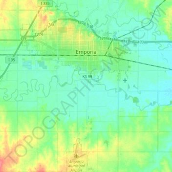
Name: Emporia topographic map, elevation, terrain.
Location: Emporia, Lyon County, Kansas, United States (38.31793 -96.24206 38.44071 -96.14053)
Average elevation: 1,135 ft
Minimum elevation: 1,083 ft
Maximum elevation: 1,270 ft
Other topographic maps
Click on a map to view its topography, its elevation and its terrain.
Humbolt Park
United States > Kansas > Lyon County > Emporia
Humbolt Park, Emporia, Lyon County, Kansas, 66801, United States
Average elevation: 1,145 ft
Americus
United States > Kansas > Lyon County > Americus
Americus, Lyon County, Kansas, United States
Average elevation: 1,161 ft
Hartford
United States > Kansas > Lyon County > Hartford
Hartford, Lyon County, Kansas, United States
Average elevation: 1,079 ft