
Childs River topographic map
Interactive map
Click on the map to display elevation.
About this map
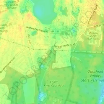
Name: Childs River topographic map, elevation, terrain.
Average elevation: 56 ft
Minimum elevation: 3 ft
Maximum elevation: 85 ft
Other topographic maps
Click on a map to view its topography, its elevation and its terrain.
South Cape Beach
USA > Massachusetts > Mashpee
South Cape Beach, Will's Work Road, Mashpee, Barnstable County, Massachusetts, USA
Average elevation: 0 ft
Quashnet Woods State Reservation
USA > Massachusetts > Mashpee
Quashnet Woods State Reservation, Whittings Road, Mashpee, Barnstable County, Massachusetts, 02649, USA
Average elevation: 46 ft
Lowell Holly Reservation
USA > Massachusetts > Mashpee
Lowell Holly Reservation, Mashpee, Barnstable County, Massachusetts, 02644, USA
Average elevation: 95 ft
Mashpee Pine Barrens
USA > Massachusetts > Mashpee
Mashpee Pine Barrens, Great Hay Road South, Mashpee, Barnstable County, Massachusetts, 02649, USA
Average elevation: 26 ft