
Rushmoor topographic map
Interactive map
Click on the map to display elevation.
About this map
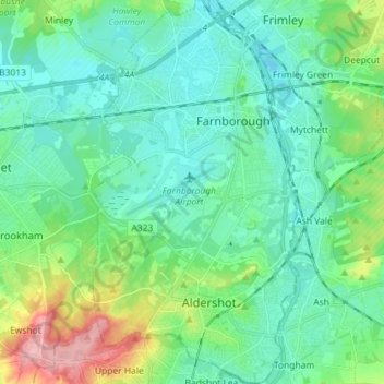
Name: Rushmoor topographic map, elevation, terrain.
Location: Rushmoor, Hampshire, South East, England, United Kingdom (51.23041 -0.80754 51.32008 -0.72934)
Average elevation: 285 ft
Minimum elevation: 187 ft
Maximum elevation: 623 ft
Other topographic maps
Click on a map to view its topography, its elevation and its terrain.
Thorn Hill
United Kingdom > England > Rushmoor
Thorn Hill, Rushmoor, Hampshire, South East, England, GU11 2DF, United Kingdom
Average elevation: 262 ft