
Pomeroy topographic map
Interactive map
Click on the map to display elevation.
About this map
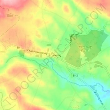
Name: Pomeroy topographic map, elevation, terrain.
Location: Pomeroy, County Tyrone, Northern Ireland, United Kingdom (54.57405 -6.94595 54.61405 -6.90595)
Average elevation: 554 ft
Minimum elevation: 348 ft
Maximum elevation: 797 ft
Other topographic maps
Click on a map to view its topography, its elevation and its terrain.
Altmore
United Kingdom > Northern Ireland > Pomeroy
Altmore, Pomeroy, County Tyrone, Northern Ireland, United Kingdom
Average elevation: 673 ft
Lurgylea
United Kingdom > Northern Ireland > Pomeroy
Lurgylea, Pomeroy, County Tyrone, Northern Ireland, United Kingdom
Average elevation: 600 ft