
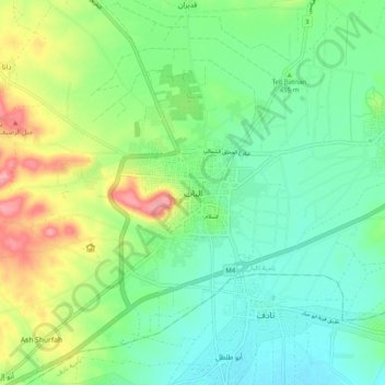
Al-Bab topographic map
Interactive map
Click on the map to display elevation.
About this map
Name: Al-Bab topographic map, elevation, terrain.
Average elevation: 1,509 ft
Minimum elevation: 1,394 ft
Maximum elevation: 1,749 ft
Al-Bab (Arabic: الْبَاب / ALA-LC: al-Bāb) is a city, de jure administratively belonging to the Aleppo Governorate of the Syrian Arab Republic. As of December 2016, the city is under the control of pro-Turkish militias, as part of the Turkish occupation of northern Syria. Al-Bab is located 40 kilometres (25 mi) northeast of Aleppo, 30 kilometres (19 mi) south of the Turkish border, and has an area of 30 square kilometres (12 square miles). Al-Bab has an altitude of 471 metres (1,545 feet). According to the Central Bureau of Statistics (CBS), it had a population of 63,069 in 2004.[1] The population has surged to about 100,000 during the Syrian Civil War.[2] Prior to the Syrian Civil War, al-Bab's inhabitants were composed of a Sunni Arab majority, and a Kurdish minority outside the city center[3]
Other topographic maps
Click on a map to view its topography, its elevation and its terrain.
Tall as Sab`in
Syria > Aleppo Governorate > تل سبعن
Tall as Sab`in, تل سبعن, Eastern Kuweires Subdistrict, Deir Hafer ِِDistrict, Aleppo Governorate, Syria
Average elevation: 1,083 ft
Tall al-Maqla
Syria > Aleppo Governorate > Aleppo
Tall al-Maqla, Aleppo, Mount Simeon Subdistrict, Mount Simeon District, Aleppo Governorate, Syria
Average elevation: 1,447 ft
Ad-Dabashiyah
Ad-Dabashiyah, Al-Jalabiyah (Chalabi) Subdistrict, Ayn Al-Arab (Kobani) District, Aleppo Governorate, Syria
Average elevation: 1,234 ft
Zahraa
Zahraa, Nubl Subdistrict, Azaz District, Aleppo Governorate, Syria
Average elevation: 1,437 ft
Khuraybah
Khuraybah, Jindires Subdistrict, Afrin District, Aleppo Governorate, Syria
Average elevation: 856 ft
Abu Shaylam
Abu Shaylam, Mount Simeon Subdistrict, Mount Simeon District, Aleppo Governorate, Syria
Average elevation: 1,115 ft
Al Hadath
Al Hadath, Al-Bab Subdistrict, al-Bab District, Aleppo Governorate, Syria
Average elevation: 1,598 ft
Mount Simeon Subdistrict
Mount Simeon Subdistrict, Mount Simeon District, Aleppo Governorate, Syria
Average elevation: 1,345 ft
`Arbid
`Arbid, Eastern Kuweires Subdistrict, Deir Hafer ِِDistrict, Aleppo Governorate, Syria
Average elevation: 1,204 ft
A`zaz
Syria > Aleppo Governorate > A`zaz
A`zaz, Azaz Subdistrict, Azaz District, Aleppo Governorate, Syria
Average elevation: 1,834 ft
Ma`arrat al `Atiq
Syria > Aleppo Governorate > Ma`arrat al `Atiq
Ma`arrat al `Atiq, Haritan Subdistrict, Mount Simeon District, Aleppo Governorate, Syria
Average elevation: 1,325 ft
Ster
Syria > Aleppo Governorate > Ster
Ster, Afrin Subdistrict, Afrin District, Aleppo Governorate, Syria
Average elevation: 938 ft
Balat
Syria > Aleppo Governorate > Balat
Balat, Al-Safirah Subdistrict, Al-Safirah District, Aleppo Governorate, Syria
Average elevation: 1,181 ft
Rayyan
Syria > Aleppo Governorate > Rayyan
Rayyan, Aleppo Governorate, Syria
Average elevation: 1,148 ft
Aleppo
Aleppo, Mount Simeon Subdistrict, Mount Simeon District, Aleppo Governorate, Syria
Average elevation: 1,355 ft
Azaz District
Azaz District, Aleppo Governorate, Syria
Average elevation: 1,621 ft
Afrin
Afrin, Afrin Subdistrict, Afrin District, Aleppo Governorate, Syria
Average elevation: 1,480 ft
Azraq
Syria > Aleppo Governorate > Azraq
Azraq, Al-Bab Subdistrict, al-Bab District, Aleppo Governorate, Syria
Average elevation: 1,732 ft
Manbij
Manbij, Manbij Subdistrict, Manbij District, Aleppo Governorate, Syria
Average elevation: 1,512 ft
Tall Butnan
Syria > Aleppo Governorate > Al-Bab
Tall Butnan, Al-Bab, Al-Bab Subdistrict, al-Bab District, Aleppo Governorate, Syria
Average elevation: 1,473 ft
Kobani
Kobani, Ayn Al-Arab (Kobani) Subistrict, Ayn Al-Arab (Kobani) District, Aleppo Governorate, Syria
Average elevation: 1,713 ft
Saharij
Saharij, Sarin Subdistrict, Ayn Al-Arab (Kobani) District, Aleppo Governorate, Syria
Average elevation: 1,486 ft