
Dale Hollow Lake topographic map
Interactive map
Click on the map to display elevation.
About this map
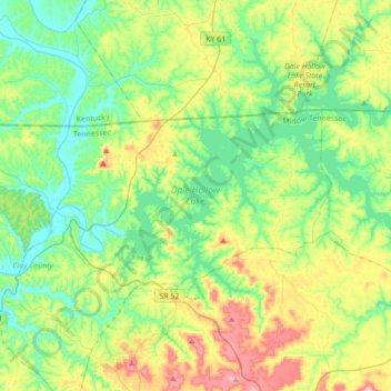
Name: Dale Hollow Lake topographic map, elevation, terrain.
Location: Dale Hollow Lake, Clay County, Tennessee, United States (36.45048 -85.46254 36.68046 -85.11435)
Average elevation: 843 ft
Minimum elevation: 505 ft
Maximum elevation: 1,634 ft
Other topographic maps
Click on a map to view its topography, its elevation and its terrain.
Cumberland River
United States > Tennessee > Clay County
Cumberland River, Clay County, Middle Tennessee, Tennessee, United States
Average elevation: 617 ft
Moss
United States > Tennessee > Clay County
Moss, Clay County, Middle Tennessee, Tennessee, 38575, United States
Average elevation: 938 ft
Celina
United States > Tennessee > Clay County
Celina, Clay County, Middle Tennessee, Tennessee, United States
Average elevation: 594 ft