
Charles Town topographic map
Interactive map
Click on the map to display elevation.
About this map
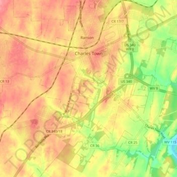
Name: Charles Town topographic map, elevation, terrain.
Location: Charles Town, Jefferson County, West Virginia, United States (39.25539 -77.90614 39.29551 -77.81743)
Average elevation: 492 ft
Minimum elevation: 325 ft
Maximum elevation: 597 ft
Due to its low elevation for West Virginia, Charles Town is on the northern extent of the Humid Subtropical climate zone, having cool to mildly cold winters and hot and humid summers. Precipitation is evenly distributed throughout the year, providing lush, abundant plant growth.
Other topographic maps
Click on a map to view its topography, its elevation and its terrain.
Harpers Ferry
United States > West Virginia > Jefferson County
Harpers Ferry, Jefferson County, West Virginia, United States
Average elevation: 571 ft
Shepherdstown
United States > West Virginia > Jefferson County
Shepherdstown, Jefferson County, West Virginia, 25443, United States
Average elevation: 413 ft
Kearneysville
United States > West Virginia > Jefferson County > Kearneysville
Kearneysville, Jefferson County, West Virginia, 25430-9047, United States
Average elevation: 531 ft
Harpers Ferry National Historical Park
United States > West Virginia > Jefferson County > Bolivar
Harpers Ferry National Historical Park, Bolivar, Jefferson County, West Virginia, United States
Average elevation: 528 ft
Halltown
United States > West Virginia > Jefferson County > Halltown
Halltown, Jefferson County, West Virginia, 25423, United States
Average elevation: 436 ft
Ranson
United States > West Virginia > Jefferson County
Ranson, Jefferson County, West Virginia, 25438, United States
Average elevation: 528 ft