
Vidalia topographic map
Interactive map
Click on the map to display elevation.
About this map
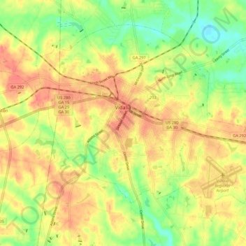
Name: Vidalia topographic map, elevation, terrain.
Location: Vidalia, Toombs County, Georgia, United States (32.17607 -82.45169 32.24776 -82.34574)
Average elevation: 246 ft
Minimum elevation: 148 ft
Maximum elevation: 318 ft
Other topographic maps
Click on a map to view its topography, its elevation and its terrain.
Santa Claus
United States > Georgia > Toombs County
Santa Claus, Toombs County, Georgia, United States
Average elevation: 223 ft