
Mousa Ali topographic map
Interactive map
Click on the map to display elevation.
About this map
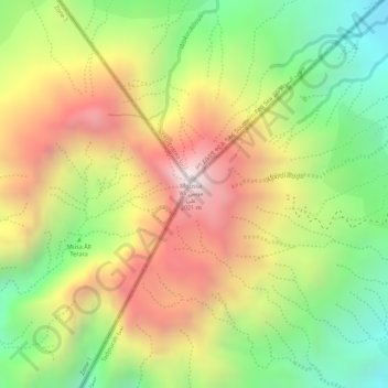
Name: Mousa Ali topographic map, elevation, terrain.
Location: Mousa Ali, Dorra District, Tadjourah, Djibouti (12.46773 42.40442 12.46783 42.40452)
Average elevation: 5,262 ft
Minimum elevation: 3,891 ft
Maximum elevation: 6,608 ft
Other topographic maps
Click on a map to view its topography, its elevation and its terrain.
Lake Assal
Lake Assal, مسار درة-بالهو / Piste Dorra - Balho, Dorra, Balha District, Tadjourah, Djibouti
Average elevation: -436 ft