
Addis Ababa topographic map
Interactive map
Click on the map to display elevation.
About this map
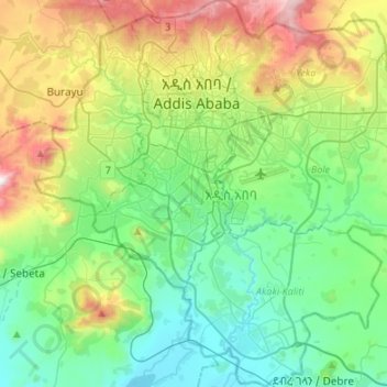
Name: Addis Ababa topographic map, elevation, terrain.
Location: Addis Ababa, Ethiopia (8.83202 38.65500 9.09840 38.90960)
Average elevation: 7,776 ft
Minimum elevation: 6,706 ft
Maximum elevation: 10,502 ft
Addis Ababa lies at an elevation of 2,355 metres (7,726 ft) and is a grassland biome, located at 9°1′48″N 38°44′24″E / 9.03000°N 38.74000°E / 9.03000; 38.74000. The city lies at the foot of Mount Entoto and forms part of the watershed for the Awash. From its lowest point, around Bole International Airport, at 2,326 metres (7,631 ft) above sea level in the southern periphery, Addis Ababa rises to over 3,000 metres (9,800 ft) in the Entoto Mountains to the north.
Other topographic maps
Click on a map to view its topography, its elevation and its terrain.
Ambassador Park
Ethiopia > Addis Ababa > Arada > Addis Ababa
Ambassador Park, Posta Bet, Addis Ababa, Arada, Addis Ababa, Ethiopia
Average elevation: 7,795 ft
Addis Ababa
Ethiopia > Addis Ababa > Arada
Addis Ababa, Arada, Addis Ababa, 3578, Ethiopia
Average elevation: 8,258 ft
Sheger Park - Phase 2
Ethiopia > Addis Ababa > Arada
Sheger Park - Phase 2, Eri Bekentu, Arat Kilo, Arada, Addis Ababa, Ethiopia
Average elevation: 7,917 ft
Meskel Square
Ethiopia > Addis Ababa > Kirkos > Addis Ababa
Meskel Square, Meshuwalekiya, Addis Ababa, Kirkos, Addis Ababa, Ethiopia
Average elevation: 7,717 ft
National Palace
Ethiopia > Addis Ababa > Addis Ababa
National Palace, Yohanis Street, Ambassador, Beherawi, Addis Ababa, 1138, Ethiopia
Average elevation: 7,772 ft